
Tartu, Estonia is the origin of the Struve Geodetic Arc, a chain of points used to measure the meridian line which passes through the heart of the city and stretches far beyond, from the Arctic Ocean to the Black Sea. Nearly 200 years ago, it provided the first accurate dimensions of the size and shape […]
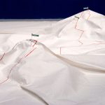
Beautification This Site

Beautification This Site, 2012-2016: An earthwork and self-assigned residency centering on a leftover piece of landscape I acquired from the NYC DOT’s Adopt-A-Highway program
Street Signs Became Flags That Mark Mountaintops
Street Signs Became Flags That Mark Mountaintops, 2012-2013: An expedition through New York City as a series of mountain climbs
Landmarks

Landmarks, 2008-: An ongoing series of photographs of discovered landmarks
A sign marks a summit

A sign marks a summit, 2012: A self-guided trail which wandered the grid of Peekskill, NY’s sidewalks, streets, longitude and latitude up to a local summit
A summit is a local point of elevation

A summit is a local point of elevation, 2011: Maps an expedition to the mountain peaks of Crown Heights, Brooklyn
Public Utility Trail Network
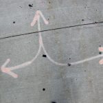
Public Utility Trail Network, 2010-2011: Maps re-interpreting the marks left by public utilities as trail markers in a network of hiking/walking trails for pedestrians