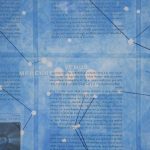
All the stars invisible in the daytime sky on the longest day of the year
This invisible line

Tartu, Estonia is the origin of the Struve Geodetic Arc, a chain of points used to measure the meridian line which passes through the heart of the city and stretches far beyond, from the Arctic Ocean to the Black Sea. Nearly 200 years ago, it provided the first accurate dimensions of the size and shape […]
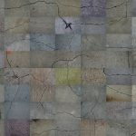
This is when the ice sheet ended
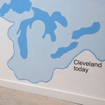
This is when the ice sheet ended, 2020: An installation of photographs, video and a free community-sourced map explore Cleveland as a post-glacial landscape
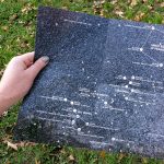
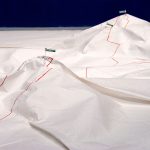
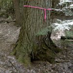
The terminal moraine is the accumulation of debris at the end of a glacier

The terminal moraine is the accumulation of earth and debris at the end of a glacier, 2019-
Storm King by the Stars
Storm King by the Stars, 2014: Constellations transform a walk among monumental sculptures into two different celestial tours
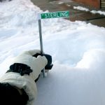
Street Signs Became Flags That Mark Mountaintops
Street Signs Became Flags That Mark Mountaintops, 2012-2013: An expedition through New York City as a series of mountain climbs
Visitor Center for Erratic Monuments
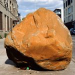
Visitor Center for Erratic Monuments, 2013-2015: An resource for interpreting peculiar boulders found along Brooklyn sidewalks
A sign marks a summit

A sign marks a summit, 2012: A self-guided trail which wandered the grid of Peekskill, NY’s sidewalks, streets, longitude and latitude up to a local summit
A summit is a local point of elevation
A summit is a local point of elevation, 2011: Maps an expedition to the mountain peaks of Crown Heights, Brooklyn
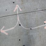
Sidewalk Drawings
Sidewalk Drawings, 2008-2013: Cracks in the sidewalk are collaged together to create a destinationless, meandering path through an imagined city landscape
Public Utility Trail Network
Public Utility Trail Network, 2010-2011: Maps re-interpreting the marks left by public utilities as trail markers in a network of hiking/walking trails for pedestrians
Trail Guide
Trail Guide, 2010: A guide book to various trail markers
Local Landmarks

Local Landmarks, 2010: A pair of guidebooks to USGS survey monuments of varying scale
Brooklyn Constellations

Brooklyn Constellations, 2007: A map of all the businesses in the local phonebook that begin with the name “star”
One step is 3.6 million miles

One step is 3.6 million miles, 2005: A walking tour of the solar system along a sidewalk in DUMBO, Brooklyn